Phoenix Arizona For The Surprise Engagement Trip Summary
 So, why are we going to Arizona in the summer? Penny Lind moved to Phoenix a few years back and met Chris, a fireman and all around great guy!
Chris decided to "pop the question" and arranged for a party with all the key players there. We are going to a country western concert where
Since we are going east, Sue and I are going to Sedona first and stay a couple of days and play golf before heading south to Phoenix. In Phoenix, we are staying at the Biltmore Hotel and also playing golf!
Lisa Chartier is traveling with us to get some adult time alone while Pete is in Iraq!
The Trip Begins (May 29th-June 4th)
We left Thursday morning and headed across I40 to Flagstaff where we turned south down 89A to Sedona. Lisa Chartier traveled with us as Pete is in Iraq and she needed some "time off" from the two teenage boys! According to Google Maps the estimated time: is 7.0 hours 27 minutes and an estimated distance: 489.96 miles. An easy drive:
 (25 miles)
 (8 miles)
 (67 miles)
 (350 Miles)
 (19 miles). We don't identify anything in California so we begin in Arizona!

GPS To The Rescue
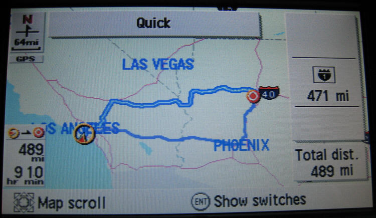
It tells us all we need to know!
Barstow, California
 Barstow is a city in San Bernardino County, California, United States. The population was 21,119 at the 2000 census.
 Barstow is a major regional transportation center. Several major highways including Interstate 15 and Interstate 40 converge in the city. It is the site of a large rail classification yard, belonging to the BNSF Railway. The Union Pacific Railroad also runs through town on trackage rights on BNSF's main line to Daggett 10 miles east, where it heads to Salt Lake City, and the BNSF heads to Chicago.
Barstow is home to Marine Corps Logistics Base Barstow and is the closest city to Fort Irwin Military Reservation.
Barstow is disproportionately represented in popular culture, due to its small population, remoteness and relative isolation. Route 66 runs through Barstow and the town's name is mentioned in the lyrics to the "Route 66".
Johnny Carson of the Tonight Show used Barstow as a target in many of his jokes. Spike Jones used Barstow in his song "Barstool Cowboy from Old Barstow." A more serious composition by Harry Partch is entitled "Barstow: Eight Hitchhiker Inscriptions from a Highway Railing at Barstow" and is based upon his travels through the Mojave desert town in

We found a great place to eat in Barstow and enjoyed getting out of the car and stretching for a few minutes before hitting the road again!
Needles, California
 Needles (Mojave 'Aha Kuloh) is a city located on the western banks of the Colorado River in San Bernardino County, California. It is located in Mojave Valley, which straddles the California-Arizona border. The city is accessible via Interstate 40 and U.S. Route 95. The population was 4,830 at the 2000 census, and was estimated at 5,700 by mid-2008. Needles was named after "The Needles," a group of pointed rocks on the Arizona side of the river. There is a relatively large Mohave community,

Mohave people had been living in the area for hundreds, if not thousands, of years prior to the European exploration of the area. In 1859, Fort Mojave was built to protect immigrants to California and other travelers from the Mohave.
The city was founded in 1883 as a result of the construction of the railroad, which crosses the Colorado at this point. The name is derived from pointed mountain peaks at the south end of the valley.
Historic Route 66 passes through the city, lined with motels and other shops from that era. Needles is a tourism and recreation center, a tradition going back for decades.
Needles, like Death Valley, is known for extreme heat during the summers. Temperatures in Needles routinely reach 120°F (49 °C) in late July and early August. The Needles weather station is frequently reported by the United State government's National Oceanic and Atmospheric Administration (NOAA) as the site of the highest daily temperature recorded in the U.S. during the hot desert summers. Needles occasionally sets national or world daily high temperature records.
On July 17, 2005, the high temperature at Needles was 125 degrees Fahrenheit (51.6 degrees Celsius), the warmest temperature ever recorded in Needles since record keeping began in 1940, breaking the previous all-time record high of 123 degrees four days earlier (which prior to that, broke the all-time high of 122 which was set on July 2, 1967)
There Was Miles And Miles Of Miles And Miles On I-40

Kingman, Arizona
 Kingman Arizona was founded in 1882. Situated in the scenic Hualapai Valley between the Cerbat and Hualapai mountain ranges. It is known for its very modest beginnings as a simple railroad siding near Beale’s Springs in the Middleton Section along the newly constructed route of the Atlantic and Pacific Railroad.
Arizona can boast the longest stretch of Route 66 still in existence between Chicago and Los Angeles. Beginning just west of Ashfork and continuing from Seligman through Peach Springs, this stretch of the original road positions
Kingman as the "Heart of Historic Route 66."
Williams, Arizona
 Williams is in Northern Arizona, 60 miles south of the Grand Canyon. The southern point of the Grand Canyon Railway is here in Williams along with several alternatives to lodging at the Grand Canyon.
 Surrounded by the Kaibab National Forest and the Bill Williams Mountain area, there is plenty of camping, scenic drives and hiking opportunities. Winter usually brings enough snow for a small ski hill and other winter sports. Summer's relatively cool temperatures and tall pine forests make Williams a very attractive destination for residents from the nearby hot deserts. Williams is located on I-40 in northern Arizona, 60 miles south of the Grand Canyon. It is 30 miles west of Flagstaff and 220 miles southeast of Las Vegas, Nevada.
Williams, Arizona would go down in history as being the last town to have its section of Route 66 bypassed. The original plan was to have the last section of the famous highway bypassed somewhere in Texas, but lawsuits that had been filed kept the last section of Interstate 40 from being built around Williams. After settlements called for the state to build three exits for the town, the suits were dropped and I-40 was built. In 1984, Interstate 40 was opened around the town and newspapers the next day reported the essential end of the famous US 66. The following year, Route 66 was decommissioned.
 Amtrak, the national passenger rail system, provides daily service to Williams, operating its Southwest Chief between Chicago and Los Angeles. Rail passengers actually arrive and depart at Williams Junction, east of Williams, and are transported by bus from Williams Junction to the downtown rail station. The downtown station also serves as the southern terminus for the Grand Canyon Railway.
We plan to take the train to the Grand Canyon later in 2008 and will be departing Williams in October.
Seligman, Arizona
 Seligman, Arizona is a Route 66 town all the way. Seligman is located at [show location on an interactive map] 35°19′42″N, 112°52′27″W (35.328199, -112.874303), at 5,240 feet in elevation. It lies on the route of Historic Route 66, and its predecessor, the Mojave Road. It's population is about 500.
According to the United States Census Bureau, the CDP has a total area of 6.4 square miles (16.5 km²), all of it land.This delightful town retains all the flavor of the old road. A trip down Route 66 in Seligman is a trip back in time to the days when Route 66 was the Main Street of America. Founded in 1895 after the completion of the "Peavine" Railroad (see Ash Fork) the railroad camp known as Prescott Junction officially became Seligman and

Seligman embraced Route 66 wholeheartedly upon its arrival in the late 1920’s.
The railroad and tourist traffic from Route 66 became Seligman's main source of economic security. In the late 1970's Seligman was bypassed by the Interstate and the Santa Fe Railroad ceased its operations in the town in 1985.
Many old towns with similar histories would have faded away once they were bypassed, but not Seligman.
I remember studying the old maps we used when going to Arkansas in the summertime.

Flagstaff, Arizona... Our Turning Point
 We "bypass" downtown Flagstaff as we leave I40 for S89 and then S89A. Flagstaff (Navajo: Kinłání) is a city located in northern Arizona, in the southwestern United States. As of July 2006, the city's estimated population was 58,213. The population of the Metropolitan Statistical Area was estimated at 127,450
 It is the county seat of Coconino County. In 2005, Men's Journal named Flagstaff as No. 2 on its Best Places to Live list, and National Geographic cited the city in its list of "10 Great Towns That Will Make You Feel Young." The city is named after a Ponderosa Pine flagpole made by a scouting party from Boston (known as the "Flagstaff Tea Party") to celebrate the United
Flagstaff lies near the southwestern edge of the Colorado Plateau, along the western side of the largest contiguous ponderosa pine forest in the continental United States. Flagstaff is located adjacent to Mount Elden, just south of the San Francisco Peaks, the highest mountain range in the state of Arizona. Humphreys Peak, the highest point in Arizona at 12,633 feet (3,850 m), is located about 10 miles (16 km) north of Flagstaff in Kachina Peaks Wilderness.

Flagstaff's early economy was based on the lumber, railroad, and ranching industries. Today, the city remains an important distribution hub with companies like Nestle Purina Petcare and Walgreen Distribution Center, and is home to Lowell Observatory and Northern Arizona University.
Sedona, Arizona (May 29th/30th)
 Located in Arizona's high desert under the towering southwestern rim of the vast Colorado Plateau, the city of Sedona is blessed with four mild seasons marked by abundant sunshine and clean air. Ideally, the annual average high and low temperatures are 74.7 and 45.7 degrees, respectively.
 We picked Sedona as our first stop because of the very wonderful time we had there twenty years ago, We picked black berries from along the river and just relaxed for several days.
Almost the entire world knows that Sedona, strategically situated at the mouth of spectacular Oak Creek Canyon, is a unique place. Characterized by massive red-rock formations, as well as the contrasting riparian areas of Oak Creek Canyon, the area surrounding this beloved community is considered at least as beautiful as many national parks.
Phoenix, Arizona (June 1st)
 Welcome to Discover Phoenix. Incorporated in 1881, Phoenix is young by historical standards but now ranks as one of the fastest-growing cities in the nation. We are staying at the Biltmore and off to see Penny/Chris or a
Country Western thing-a-ma-bob
???
Welcome to Discover Phoenix. Incorporated in 1881, Phoenix is young by historical standards but now ranks as one of the fastest-growing cities in the nation. We are staying at the Biltmore and off to see Penny/Chris or a
Country Western thing-a-ma-bob
???
The Biltmore Hotel
 The Arizona Biltmore Resort & Spa is nestled on 39 acres at the foot of the Phoenix Mountain Preserve. Considered one of the most spectacular resorts in the world, the Biltmore features 738 guest accommodations, including 78 one- and two-bedroom villas, eight swimming pools, seven tennis courts, an 18-hole putting course, and a full-service European spa, salon, and fitness
Biltmore Golf
The adjacent Arizona Biltmore Country Club offers two 18-hole PGA golf courses, The Links and The Adobe.
The Return (June 2nd)
Easy... Head down I10 to home!
